From the perspective of Europe, South America was discovered by Columbus at the mouth of the Orinoco in 1498.
Brazil was settled by Portuguese in the early part of the 16th century. The Portuguese language is spoken there. It declared itself free from Portugal in 1822 and became an empire.
The Pacific Ocean was discovered by Balboa, who crossed the Isthmus of Panama in 1513, and soon after, by Magellan, who entered the Pacific through the strait which bears his name, and thus made the first voyage around the globe.
Balboa was followed by Pizarro, a cruel Spaniard who conquered Peru, which then included nearly the whole of the western part of South America and was inhabited by a powerful and civilized race.
Peru was held by Spain for about three hundred years, and in the early part of the 1800s all the Spanish colonies, from Venezuela to Chili, inclusive, became independent.
The South American republics, like Mexico, have historically suffered much from revolutions.
TOPICAL GEOGRAPHY
South America:—What can you say of its position on the globe? Its shape and measurements? Its mountain ranges, volcanoes, and plateaus? Its climates? Rains and droughts, and their effects? Vegetable products? Minerals? Exports? Animals? Inhabitants, original and present? Governments? Discovery and history?
If the winds of the tropical countries blew from the Pacific instead of the Atlantic, would Brazil have abundant rains, large rivers, and dense forests? Why? Would it, in that case, be wet or dry, on the west side of the Andes? Where, then, would be the rainless districts?
If the Andes were along the Atlantic coast, instead of the Pacific, what would be the effect? In southern Chili and Argentina, the winds blow from the Pacific; on which side of the Andes, in those countries, does the most rain fall? Where are their rainless districts?
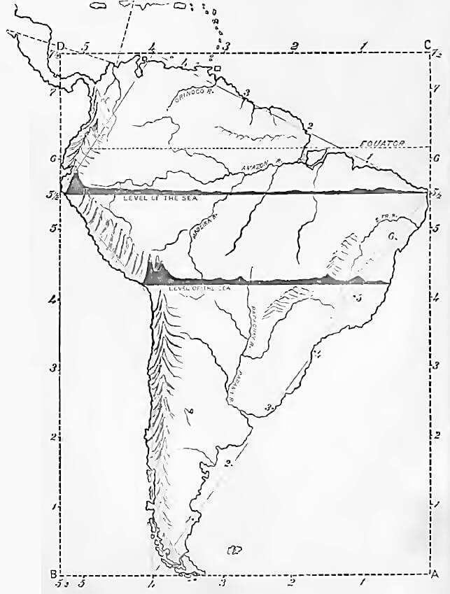
DRAW SOUTH AMERICA
Draw South America on pg. 19 in your notebook as directed.
Commence at A, and move 5 1/2 measures north, and mark Cape St. Roque. Measure to C, 7 1/2 measures; then west to D, 5 1/2 measures. At 4 measures from C, mark Cape Gallinas and Lake Maracaybo. From 5 1/2, at Cape St. Roque, toward 4 on the line C-D, mark the points, 1, near the mouth of the Amazon River; 2, opposite Georgetown; and, 3, near Caracas. Complete the coast line.
From A, toward the west, mark the points 4 and 5 1/2 at B. From 4, west of A, toward Cape St. Roque, mark 1 near the Gulf of St. George; 2 opposite St. Matthias' Bay; 3 near the mouth of the Rio de La Plata; and 6, opposite the Bay of All Saints. Complete the coast line.
From 4, west of A, move 4 measures north, and draw the coast south to Terra del Fuego and Cape Horn.
North of B, mark the points 5 1/2, 6, 7, and draw the Gulf of Darien, Isthmus of Panama, and Cape Blanco. Complete the drawing by marking the mountains, rivers, countries, bays, gulfs, capes, cities, etc., writing the full name of each outside the map.
 Comprehensive Geography
Comprehensive Geography
Comprehensive Geography


 About
About Curriculum
 Navigation